
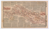
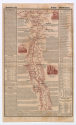
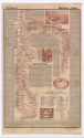
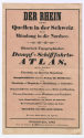
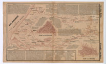
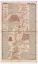
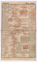
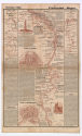
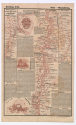
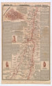
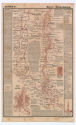
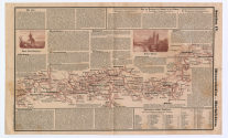
, DER RHEIN von den Quellen in der Schweiz bis zur Mündung in die Nordsee. Hostorisch - Topographischer DAMPF-SCHIFFAHRTSATLAS in dreizehn Sectionen, 1842")


Object numberSch.2019-82
DER RHEIN von den Quellen in der Schweiz bis zur Mündung in die Nordsee. Hostorisch - Topographischer DAMPF-SCHIFFAHRTSATLAS in dreizehn Sectionen
UntertitelSection I. Quellen - Chur. Section II. Chur - Bodensee. Section III. Rheineck - Dissenhofen. Section IV. Dissenhofen - Rheinfeldern. Section V. Basel - Markolsheim. Section VI. (Strassburg.) Artolheim - Iffezheim. Section VII. Selz - Mannheim. Section VIII. Frankenthal - Bingen. Section X. Sinzig - Bingen. Section XI. [unkannt]. Section XII. Emmerich - Wyk. Section XIII. Utrecht - Nordsee.
NameKarte/Plan
Verleger*in
Georg Ritter
(DE, 1795 - 1854)
Besitzer*in
SchifffahrtMuseum Düsseldorf
Eigentümer*in
Landeshauptstadt Düsseldorf
Date1842
MediumBuchdruck, Lithografie auf Papier, Pappschuber mit kaschiertem Titelblatt, Druck auf Papier, Goldfarben auf Schwarz
DimensionsAußenmaß (H x B x T) (Schuber): 19,9 × 12,3 × 1,1 cm
Blattmaß (je): 23,5 × 38,7 cm
DescriptionTitelblatt und 12 lose Blätter im SchuberBlattmaß (je): 23,5 × 38,7 cm
Klassifikation(en)
Curatorial Remarks14
Copyright Digitalisat© Kulturamt der Landeshauptstadt Düsseldorf
Institution
SchifffahrtMuseum Düsseldorf
Department
Schifffahrtmuseum - Objekte
![[[missing key: :media.image-unavailable-label]]](/assets/skin/z56c3851/images/Platzhalter.svg)

Zarah Leander


Union Deutsche Verlags-Gesellschaft
Erscheinungsjahr: 1925
