
, Rheinpanoramakarte \"Der RHEIN VON MAINZ BIS KÖLN\", 1. Hälfte des 20. Jahrhunderts")

Object numberSch.2023-22
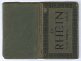
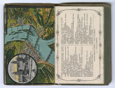
Rheinpanoramakarte "Der RHEIN VON MAINZ BIS KÖLN"
NameKarte/Plan
Verlag
Kunstverlag Wizico, Cöln am Rhein
(DE, 20. Jahrhundert)
Besitzer*in
SchifffahrtMuseum Düsseldorf
Eigentümer*in
Landeshauptstadt Düsseldorf
Date1. Hälfte des 20. Jahrhunderts
Medium15 Postkarten und Legende als Leporello gefalten in Buchumschlag geklebt, Druck auf grünem Karton (Buchumschlag), Offsetdruck auf Karton (Postkarten, Legende)
DimensionsAußenmaß (H x B x T) (Buch, geschlossen): 14,6 × 9,4 × 1 cm
Außenmaß (H x B x T) (Buch, geöffnet): 14,6 × 19,5 cm
Blattmaß (Karte, aufgeklappt): 14,6 × 143,3 cm
DescriptionRheinpanoramakarte "Der Rhein von Mainz bis Köln"Außenmaß (H x B x T) (Buch, geöffnet): 14,6 × 19,5 cm
Blattmaß (Karte, aufgeklappt): 14,6 × 143,3 cm
Klassifikation(en)
Copyright Digitalisat© Kulturamt der Landeshauptstadt Düsseldorf
Institution
SchifffahrtMuseum Düsseldorf
Department
Schifffahrtmuseum - Objekte

Hoursch & Bechstedt Buch- und Kunstverlag
1. Hälfte des 20. Jahrhunderts

Verlag Photogr. Kratz
2. Viertel des 20. Jahrhunderts

J. Halenza'sche Verlagsbuchhandlung (Mainz)
Ende des 19. Jahrhunderts

Lithographische Kunstanstalt Carl Garte
Ende des 19. Jahrhunderts

Hoursch & Bechstedt Buch- und Kunstverlag
1. Hälfte des 20. Jahrhunderts

Hoursch & Bechstedt Buch- und Kunstverlag
1. Hälfte des 20. Jahrhunderts

Verlag von K. Suder
1. Hälfte des 20. Jahrhunderts
![[[missing key: :media.image-unavailable-label]]](/assets/skin/z56c3851/images/Platzhalter.svg)


Johann Adam Bühler
1858